Camping - Hungry Mother State Park - Marion, Virginia - October 2022
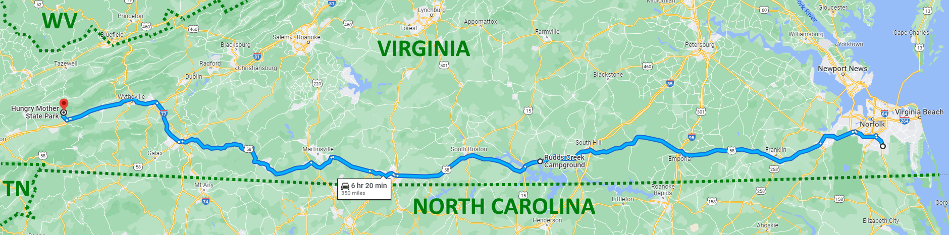
I spent a week at Hungry Mother State Park in Marion Virginia. Hungry Mother is one of the original six Virginia State Parks which all opened on the same day in 1936 to create the Virginia State Park system. The park is 360 miles due west of Hampton Roads near the extreme southwest corner of Virginia. Since it was such a long distance to tow the camper, I stopped overnight in Clarksville, Virginia (which is about halfway) on the way out and on the way back to break up the drive. (See map below.)
I stayed at Rudds Creek Campground located on the John H. Kerr Reservoir. The campground is run by the US Army Corps of Engineers. My campsite backed right up to the lake, so I had beautiful views. And it was only $28 for the night with electric and water hookups. The folks in the back loop of the campground had their sites all decorated for Halloween. The campground was very nice. The sites were arranged in small loops with most of the sites backing up to the lake. There's a boat ramp and a swimming beach right in the campground. Several sites had their boats pulled up to the shoreline behind their campsite.
Hungry Mother State Park was made possible due to a donation of 1,881 acres of land to the state for the establishment of a state park in Smyth County on Hungry Mother Creek in 1933. Later that year, the Civilian Conservation Corps (CCC) began construction of Hungry Mother and the five other state parks. Roads, trails, picnic areas, cabins, a restaurant, a bathhouse, a dam and a sanitation system were all built by the 600 CCC men at the park between 1933 and 1941. The park has a 108 acre lake which was created by the impoundment of Hungry Mother Creek. The lake elevation is 2200'. You can read more about the history of the name "Hungry Mother" on the park's website under "The Legend of Hungry Mother". The story also lead to the name of the nearby mountain, Molly's Knob. It's a sad story, though. The park currently has 3,334 acres and is listed in the National Register of Historic Places due to the historic features.
https://www.dcr.virginia.gov/state-parks/hungry-mother
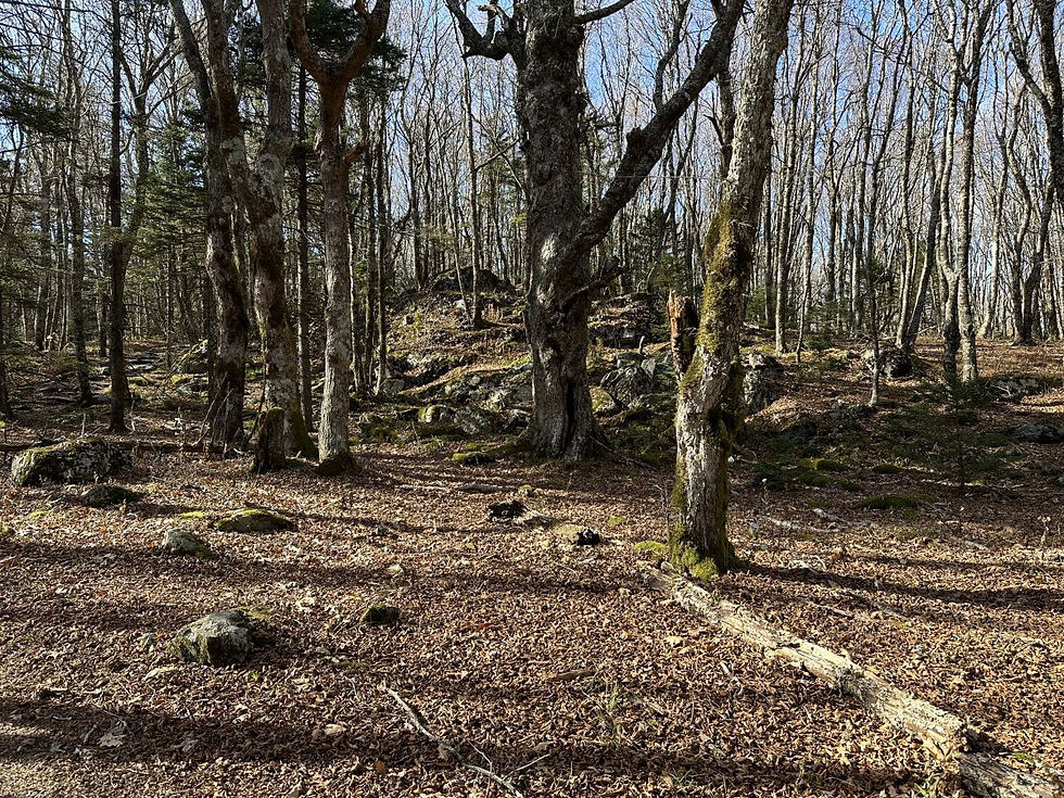
The park has several campgrounds with a total of 80 campsites. I stayed in the Creekside Campground, which as the name implies, is right on Hungry Mother Creek. There are 19 campsites in this campground. I stayed in site number 14 which backs right up to the creek. The site had a fire-ring, picnic table, small tent pad, and lantern holder. The sites overall in this park were nice although a bit small. The park and the views around the lake are spectacularly beautiful. The park has a boat ramp on the end of the lake, a large swimming beach, rentals of canoes, kayaks, paddleboards, and paddle boats. It also had a ton of trails. The trails around the shelters and beach area are all paved. There's a small island in the lake that can be accessed via a pedestrian bridge. There's a small amphitheater on the island.
Throughout the week, I visited a number of local attractions and sites including all the other state parks in this far southwest corner of the state. As you'll see, I did a lot of driving! And thus what follows is a loooooong story. Here we go!
On Monday, I drove down to Damascus, Virginia (population 653) which is about 42 minutes from Hungry Mother. (Fun fact: Damascus is only about 1.5 miles from the Tennessee border.) Damascus calls itself "Trail Town USA" due to the fact that the Appalachian Trail and the Virginia Creeper Trail (two nationally known trails) intersect with the town. Also intersecting the town is the Overmountain Victory National Historic Trail (which is a National Park Service site) and the Iron Mountain Trail which was part of the Appalachian Trail until 1972. (Side note: In the southern regions of the Appalachians, the word "Appalachian" is pronounced with the third syllable sounding like "latch".)
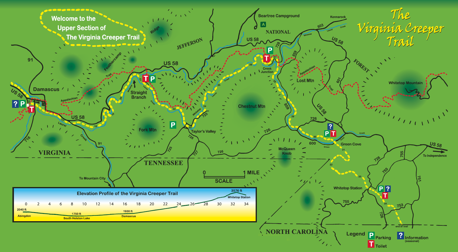
The Virginia Creeper Trail had its beginnings as a Native American footpath and was later used by pioneers and explorers such as Daniel Boone. The trail today runs on a rail right-of-way that dates to the late 1880s. It was an active railway until 1977 first transporting timber and later transporting freight and passengers. The idea of creating a trail on the abandoned railway started with a member of the Washington County Planning Commission.
In 1989, the 34 miles of converted rail line from Whitetop Station through Damascus to Abingdon opened to the public as a shared-use hiking, biking, and equine recreational trail. The trail has a smooth, hard packed surface of dirt, crushed cinders, and fine gravel. It is a National Recreation Trail. The trail was inducted into the Rail-Trail Hall of Fame (who knew there was such a thing) in 2014.
The section of the trail from Whitetop Station (near the North Carolina border) to Damascus is 17 miles long and is (mostly) all downhill. The elevation change along the trail is moderate. At Whitetop Station, the elevation is around 3500' and Damascus is around 1900' – an elevation change of around 1600' in 17 miles. (And again, in this direction, it's downhill. Wheeee!!) From Damascus to Abingdon, the trail inclines slightly, with an elevation increase of less than 300’ along the remaining 17 miles. (See the map below.)
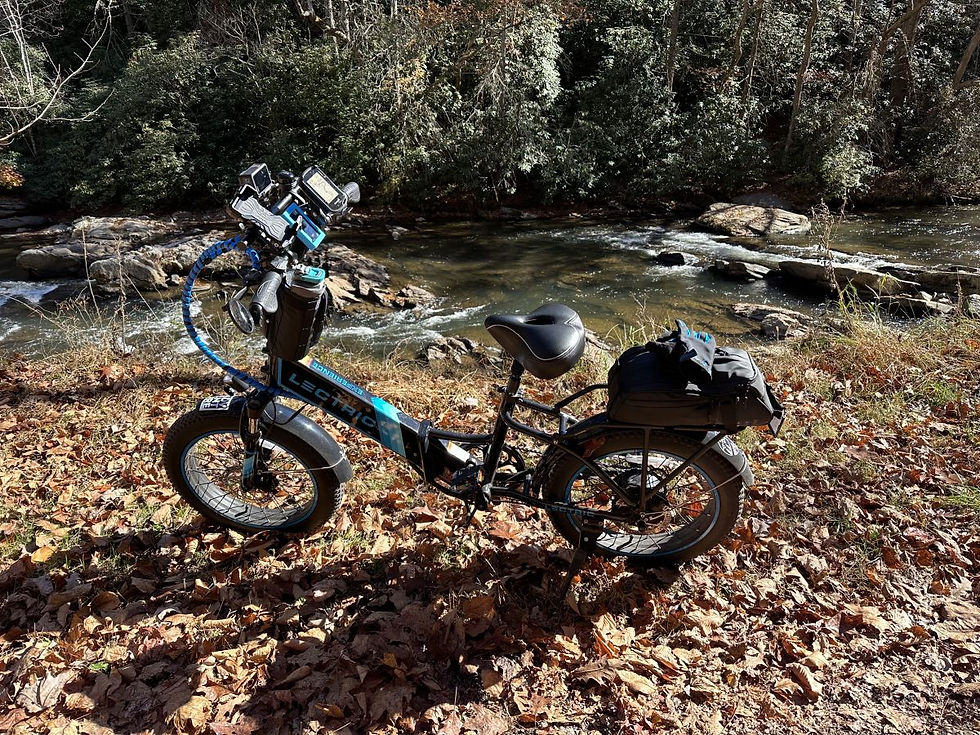
I grabbed a shuttle through Adventure Damascus, one of the many bike shops in Damascus, to Whitetop Station (which is a replica depot and visitor center) and biked back downhill to the town. The trail runs along the Laurel River which is renowned for trout fishing and provides for beautiful scenery along the trail. There are almost 50 wooden bridges and trestles (they all have numbered plaques on them) in this section that winds through the mountains of Jefferson National Forest. Along the way, i checked out Green Cove Station (which is the only original remaining depot building along the trail). There was a large crew of workers performing maintenance and repair activities on the historic structure. The depot served as post office, general store, and freight office when the railroad was active and now serves as a US Forest Service Visitor’s Center.
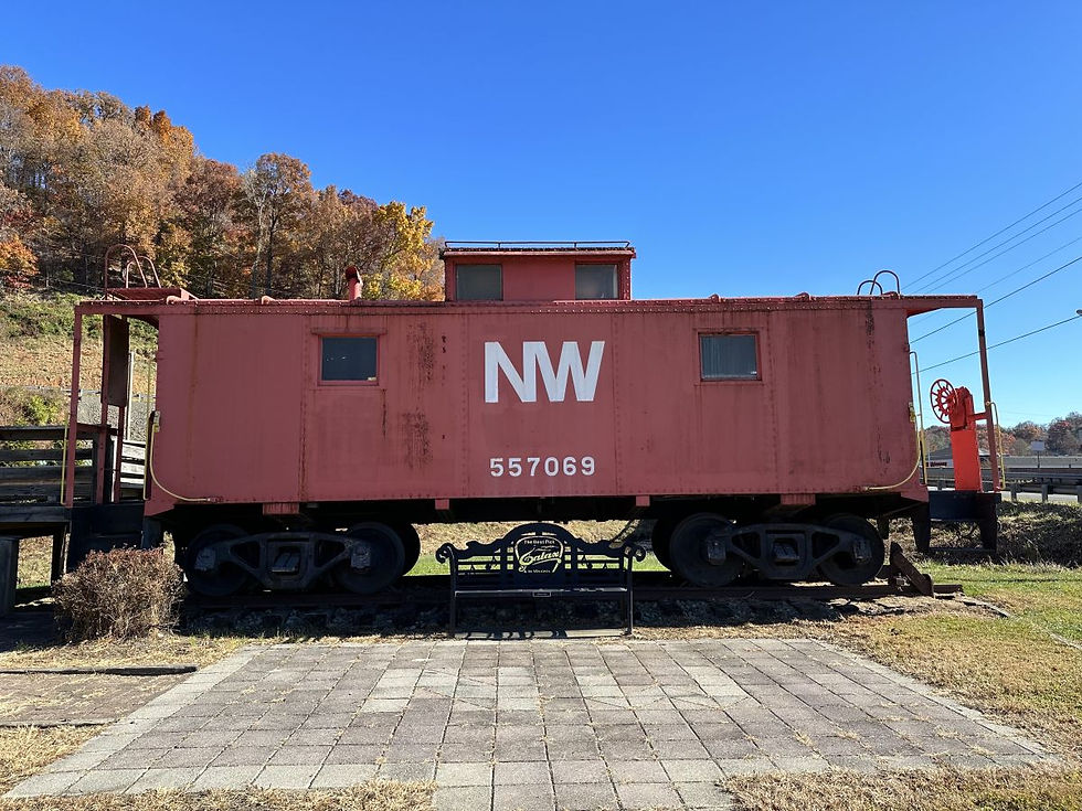
Once I got back to Damascus, I stopped at the the town park where there is a cool train caboose on display and then then drove past the town for another 7.6 miles to Alvarado where there's a old train station. Then I rode from Alvarado for another 1.5 miles to an awesome (600 feet long!) curved bridge over the Holston River. The water on the south fork of the river was SUPER low. You can see some boat docks that are sitting on the sand with no water even close to them. Hopefully, the water level gets higher during other parts of the year.
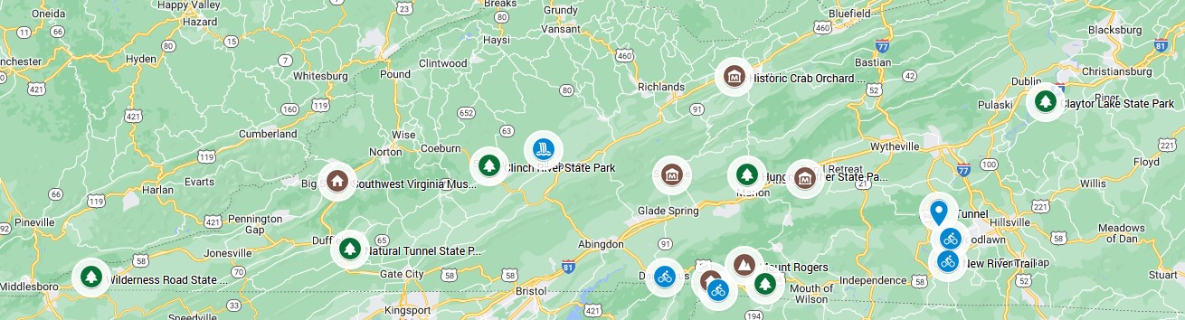
From Damascus, I went to Grayson Highlands State Park which is about 45 minutes from Damascus. Grayson Highlands, originally named Mount Rogers State Park, was established in 1965. The park is near Mount Rogers and Whitetop Mountain which are Virginia's two highest mountains. Mount Rogers is the highest natural point in Virginia with a summit elevation of 5,729 feet. (Yeah, Nate ... baby mountains.) The Mount Rogers area contains a unique record of the geohistory of Virginia. There is evidence from the rocks that volcanoes were part of the landscape.
In addition to being the gateway to Mount Rogers, Grayson Highlands State Park is known for wild ponies. The ponies were introduced to the park in the 1970s by the US Forest Service to prevent reforestation of the highland balds which are dominated by large rocky outcroppings clear of vegetation except for the occasional windswept tree and low grasses.. The Wilburn Ridge Pony Association manages the pony herd. During fall roundups of ponies for an auction held in conjunction with Grayson Highland’s annual Fall Festival, association members check the herd for health problems. The herd numbers around 150 ponies. Unfortunately, I did not see any ponies during my visit. (I guess this means i have to come BACK!!) I hiked to the Little Pinnacles and got some fantastic mountain views.
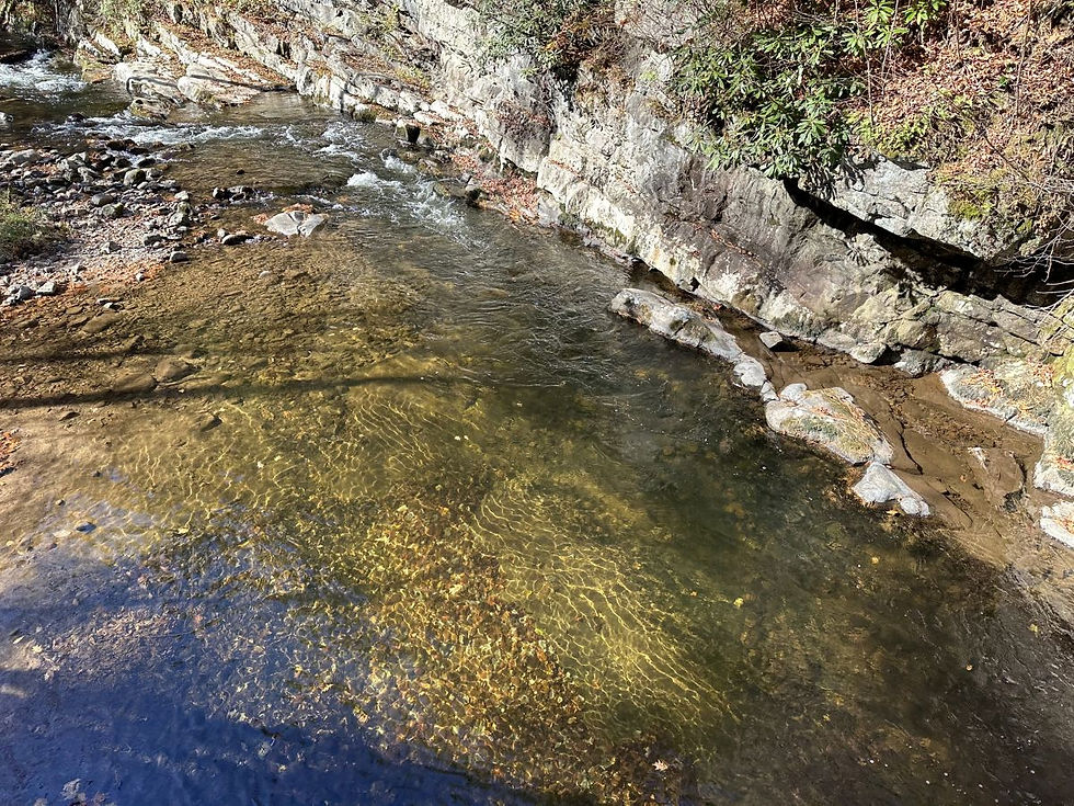
On Tuesday, I visited Clinch River State Park. This is a brand new Virginia State Park that is currently under development. The park was dedicated in 2021. It is open for hiking, biking, and fishing. The park currently has 8 miles of hiking trails, a picnic shelter, over 2 miles of river frontage, and cultural and historical features. It will eventually have additional amenities and will highlight the Clinch River’s natural, historical and recreational resources. It will be the first blueway state park in Virginia and will consist of several smaller (250-400 acres) anchor properties connected by multiple canoe/kayak access points along a 100-mile stretch of the Clinch River. The Clinch River is beautiful and peaceful and absolutely crystal clear.
From Clinch River, I went to Southwest Virginia Museum Historical State Park which is an 1890s Victorian stone mansion with an original oak interior and is located in Big Stone Gap, Virginia. The museum's collection includes more than 60,000 pieces and has exhibits telling the story of the exploration and development of Southwest Virginia from the pioneer era of the 1700s to the mining "boom and bust" era of the late 1800s. The mansion is a National Historic Landmark. From the outside, it looks like it could feature in a scary movie as a haunted house. Inside the museum, volunteers were setting up Christmas decorations. The museum also has a large quilt collection some of which are on display in one of the rooms of the mansion.
Next I drove to Cleveland, Virginia, which is a town of about 200 people. The town contains Tank Hollow Falls which can be accessed via a 0.5 mile trail in the Cleveland Barrens Natural Area Preserve. The hike to the falls is short and relatively flat and level. The town's park contains a cool suspension bridge over the Clinch River and a wooden boardwalk and trail along the river.
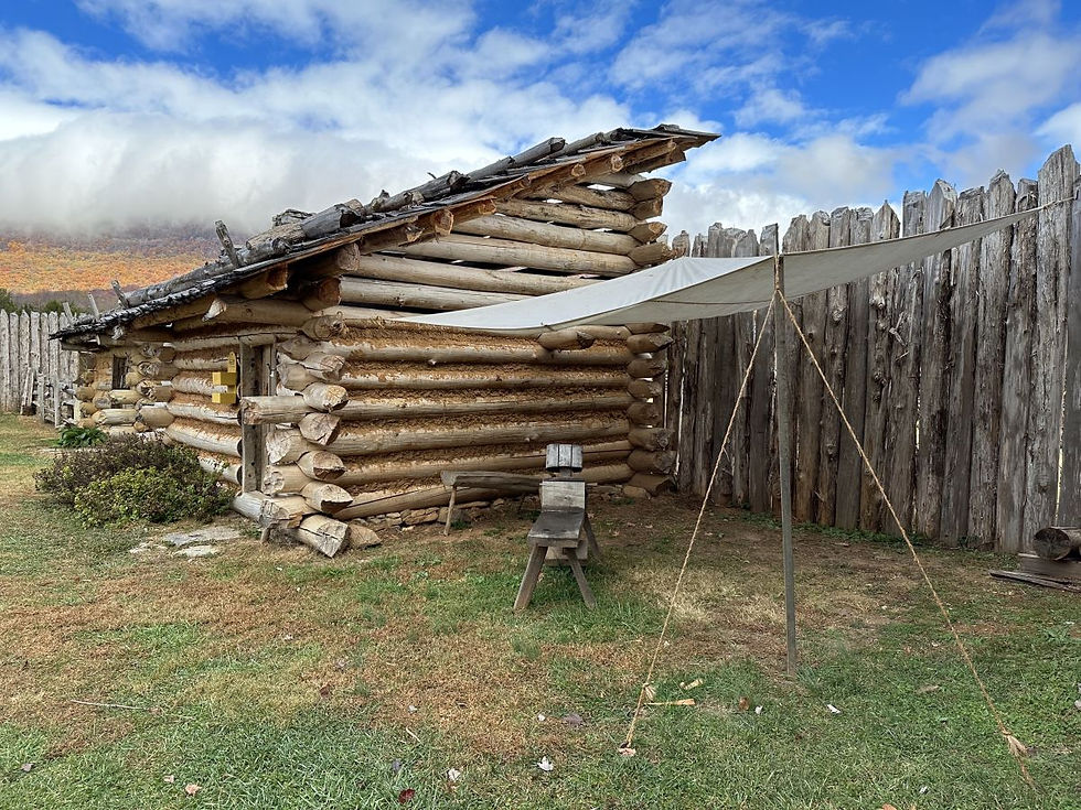
On Wednesday, I drove to Wilderness Road State Park which is about 2.5 hours (135 miles) from Hungry Mother. It's the furthest west Virginia State Park and is only about 2.5 miles (as the crow flies) from both Tennessee and Kentucky. This area is a very historically and geographically significant region of Virginia. The park lies along the Wilderness Road. In 1775, Daniel Boone carved the Wilderness Road, and by 1800 more than 300,000 settlers traveled the Wilderness Road westward through Cumberland Gap into Kentucky and the Midwest. The park contains Martin Station (now reconstructed) which was originally settled by Joseph Martin, who arrived there in early 1769 after a difficult journey. That fall, after an attack by Native American warriors, Martin abandoned the station but returned in January 1775. The reconstructed Martin's Station is an outdoor living history museum depicting life on Virginia's 1775 frontier. The Wilderness Road Trail, which is 8.5 miles long and is another rail-trail, bisects the park. Since I had a long drive planned today, I didn't bike the trail this time. NEXT TIME!!
On the way back to the campground, I stopped at Natural Tunnel State Park. Natural Tunnel was naturally carved through a limestone ridge over thousands of years. It is more than 850 feet long and 100 feet high. It opened as a state park in 1971. William Jennings Bryan called the tunnel the "Eighth Wonder of the World." The tunnel itself began its formation in the Pleistocene period (over a million years ago). The tunnel is so massive that it is still in use as a railroad tunnel. The park has a chairlift that operates on weekends to take visitors down to a wooden boardwalk to view the tunnel. Since the trails down to the track level were quite steep and it had rained, I choose to view the tunnel from the trails above the tunnel. The interpretive signage indicates that the tunnel is still "growing" and in a thousand years, the water from above will have eroded it away and it will be gone.
On Thursday, I visited the city of Galax, Virginia which is just over an hour away. Galax contains the New River Trail State Park which is a 57 mile linear park that follows an abandoned railroad right-of-way. The park parallels the scenic and historic New River for 39 miles and passes through four counties in addition to the city of Galax. Last year, I hiked on a few parts of the trail, but this year I brought my bike, so I biked from Galax to Fries Junction (12 miles) and back. Fun fact - Galax is known as the “World Capital of Old Time Mountain Music”.
From Galax, I drove to the Blue Ridge Music Center, 12 miles south, at Milepost 213 on the Blue Ridge Parkway. The music center was established by Congress to commemorate the historic roots of American music. The facility includes an outdoor amphitheater, interpretive center, luthier shop (which is a maker of stringed instruments), and natural areas. The visitor center houses the Roots of American Music Museum exhibit and a gift shop.
The Roots of American Music exhibit tells the story of the region’s rich musical heritage. From the old-time string bands, ballad singing, and dancing that define the traditional music of Southwest Virginia, Northwest North Carolina and Tennessee, to blues influences and growth of bluegrass, the exhibit traces the musical origins of the roots-based folk and Americana music of today. The museum explores how the blending of the sounds of the banjo and fiddle on the Appalachian frontier led to virtually all forms of American music. They host a free concert every day from noon to 4pm called "Midday Mountain Music", which features local and regional music. There were two gentlemen playing when I walked up. One was playing guitar and the other mandolin.
From the music center, I drove for about 10 miles up the Blue Ridge Parkway and then up I-81 to Claytor Lake State Park, which is about an hour away. Claytor Lake was formed when Appalachian Power Company built a dam on the New River, just south of Radford, in 1939. In early 1944, the people of the surrounding area expressed an interest in the establishment of a state park on the new lake. The idea continued to grow, and in 1946 private citizens and businesses from Pulaski, Radford, and Blacksburg raised the money needed to purchase 437 acres from Appalachian Power. This land was given to the state to be developed as Claytor Lake State Park. The Division of State Parks took over the operation of the park in 1951. In 1962, 35 additional acres were purchased, bringing the total acreage to 472 making it one of the smaller Virginia State Parks. But oh my is it beautiful. I definitely need to come back during warmer weather and check out the lake.
Claytor Lake has an underwater webcam pointed at an artificial underwater fish habitat made out of PVC (MossBack Fish Habitat), and you can observe fish swimming by. https://dzignorclaytorlake5.wixsite.com/claytorlakespa/videos
On Friday, I stopped by the Settlers Museum of Southwest Virginia which is about 23 min (15 miles) from the park. It is a 67 acre open-air museum that exhibits the typical farm culture of the people who settled in the mountains of Virginia. The visitor center was closed, but they had a very well done guide with a map and descriptions of the site and the features. The people who came to these mountains in the mid-1700s were primarily from two groups, the Scotch-Irish and the Germans, who carved their farms from the wilderness and formed the mountain culture. The farm, with its restored farmhouse and nine preserved outbuildings, and the 1894 schoolhouse provide a great example of rural life in this area in the late 19th century. The schoolhouse is right on the Appalachian Trail and is open to hikers and had an area for gear and clothing and other stuff for hikers.
Next, I visited the Historic Crab Orchard Museum (LAST STOP) which is about a hour drive from the Settlers Museum. The museum’s mission is to identify, collect, preserve, interpret, and promote the diverse Appalachian cultural heritage of Southwest Virginia and the surrounding region. The museum’s Pioneer Park, which was developed in the late 1970s, consists of 15 historic log and stone structures and an exhibition building. If you know me, you know that I visit a lot of museums. This museum and its outdoor exhibits were very, very well done. They tell the story of the settlers in this area from the beginnings of the exploration and hunter/trapper culture, to their farm culture, through the Revolutionary War and the Civil War; (Exhibits explained the use of flax to make linen as it is too cold to grow cotton.); through the beginning of the industrial age and the advent of coal mining; to the impact of the railroad. Both the Crab Orchard Museum and the Settlers Museum explained the importance of fruit orchards to the survival of the people. This isn’t really something I had considered before. You always think about crops and even kitchen gardens, but fruits were equally important to their survival, so they always planted fruit trees when establishing a farm
This was my last trip of the year. I drove a over 1700 miles over 9 days. It was a great trip, and there was so much in the area to visit. I may need to come back in the future and see different things and see things during different season. Now I get to start planning next year’s trips!
Campsite Details
Site 19 - $35/night
Check in Time 4:00 PM
Check out Time 1:00 PM
Electricity Hookup - 20-30-50
Water Hookup - Yes
Maximum Number of People 6
Pets Allowed - Yes
Max Number of Vehicles - 2
Driveway Surface - Paved
Site Type - Back In
Full Shade
Site Length - 60
Site Width - 20
Tent Pad Length - 20
Tent Pad Width - 20
Max Vehicle Length - 60
Campfire Allowed - Yes
Fire Pit - Yes
Picnic Table - Yes
Proximity to Bathhouse - 400
Hungry Mother Park and Campsite


Rudds Creek Campground


Virginia Creeper Trail / Damascus


Grayson Highlands State Park


Clinch River State Park


Southwest Virginia Museum Historical State Park


Tank Hollow Falls


Wilderness Road State Park


Natural Tunnel State Park


New River Trail State Park


Blue Ridge Music Center


Settlers Museum of Southwest Virginia


Historic Crab Orchard Museum
(warning lots of pictures because I tried to take pictures of all the explanatory signs)