Sunday, July 25, 2021 - Shingle Landing, North Carolina - Northwest River
Today, I drove just over the North Carolina-Virginia border to launch from Shingle Landing in Moyock, North Carolina. The launch is in the very back of a small neighborhood. The parking area has room for about a dozen vehicles (although that capacity was taxed today). There were vehicles and trailers parked all over the place. But I didn't have any problem launching.
Shingle Creek connects with the Northwest River about 3/4 of a mile south of the Virginia-North Carolina border.
Once I got into the creek, several boats passed me on the way out. In general, the boats were very respectful and slowed way down as the passed. There was a lot of boat activity out on the main river.
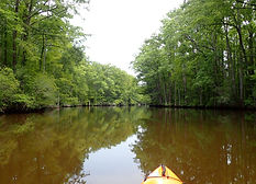
After I got to the main river, I went to the left and stayed in the smaller (protected) creek that loops through the marsh. On these smaller creeks, you typically can see various types of waterfowl nesting boxes. Some of them are in better condition than others. I also came across a few duckblinds.
When I got to the thickest part of the marsh where the creek is its narrowest, the underwater vegetation was really thick. But this early in the season, it doesn't impede paddling as long as you stay in the center.
After I exited the small creek through the marsh, I could see the Virginia-North Carolina state border marker. It is located in the middle of the widest part of the main river. But there were no powerboats around, so I paddled safely across to the marker. At this point, the wind had picked up and was right in my face as a I paddled south in the main river back toward Shingle Creek. The wind made this part of the paddle a bit challenging. And again, there were lots of boats out. Most of them were pulling wakeboards.
Once, I got back to Shingle Creek, the wind was diminished by the protection of the trees. I saw groups of kayakers going out and coming back in. Very busy day on the water.
Lovely, peaceful day paddling.
2 hours 45 minutes on the water and 5.2 miles on the GPS. Scroll below the pictures to see the track map.