
ALASKA
Ketchikan
July 2023
HAPPY FOURTH OF JULY!!!!!!!
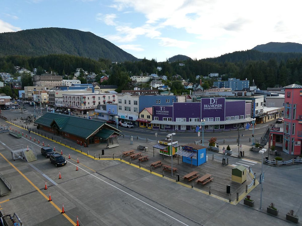
Alaska's "First City" of Ketchikan is so named because it’s the first major landfall for most cruisers as they enter the picturesque fjords of the Inside Passage. The city clings to the banks of the Tongass Narrows, flanked by green forests nurtured by abundant rain. Ketchikan is located on the large Revillagigedo Island. Location 55°20'N 131°38'W. The two other cruise ships in port with us today were Discovery Princess and Carnival Luminosa.
Known also as the "Salmon Capital of the World", Ketchikan is notable for its rich native culture, salmon fishing, and scenic fjords. Ketchikan has long been an important hub of the salmon fishing and packing industries. In the late summer months, salmon gather by the thousands to spawn upstream. Ketchikan is also a great spot along the Inside Passage to explore the rich cultural sights of Native Alaskan nations like the Tlingit, Haida, and Tsimshian.
The city is also known as the "Rain Capital of Alaska" and experiences on average over 150 inches (12.5 FEET!) of rain per year. This area gets more rainfall than anywhere else in North America. It rains (or snows) 229 days per year on average. Liquid Sunshine. The visitor's bureau has a "Liquid Sunshine" rain gauge right down by the cruise dock tracking how much rain there has been each year. It did not rain while we were there. In fact, the temperature was almost 80 degrees. Fantastic summer day!
Ketchikan is 4.9 square miles in size including just over 1 square mile of water. The downtown "tourist" area near the cruise docks is less than a third of a square mile. It's compact. The city was incorporated in 1900. There are no roads into or out of Ketchikan. All access is via air or water (a common thing for Alaska cities and towns). Ketchikan is home to around 8000 residents. On an average day in the summer, between 6000 and 8000 cruise passengers embark on the city.
Since Ketchikan is so small and there's a lot to do and see in town, I decided to spend the day in port exploring the museums, parks, shops, and other sites around town. Since Holland America has been cruising to Alaska for so long, they have excellent docking privileges in the various ports. We docked at Dock 1 which is directly adjacent to the Ketchikan Visitors Bureau.
Creek Street is a historic boardwalk perched on pilings along the banks of Ketchikan Creek. It opened as the "entertainment district" in 1903. Yeah, it was formerly a redlight district. I walked along the historic Creek Street boardwalk checking out the former brothels, which are now a row of colorful shops, up close. The saying on a sign is "where both men and salmon came upstream to spawn".
At the end of Creek Street is the "Married Man's Trail". This was the route that married men used to frequent the “sporting women” who worked in the brothels of Creek Street. The working women knew which men were married by the mud on their boots. Small boats also brought illegal alcohol to the establishments during Prohibition going under the raised boardwalk. Many of the Creek Street houses had trapdoors where they could receive alcohol deliveries under the dock in the dark of night.
Along the creek where the Married Man's Trail reaches the street is a structure called the salmon ladder. Salmon swim up Ketchikan Creek to spawn in the late summer. The salmon have some difficulty getting up the rapids in the creek, so years ago the salmon ladder was built to help them out. It looks like a set of concrete stairs with a lip that keeps some water in the ladder.
From the salmon ladder overlook, I headed up the hill about a quarter mile to PITTINGER AVENUE!! When I saw the street name on the map, I knew I had to take a little detour to check it out. In doing some research, I found a reference to "Jacob Pittenger's Dairy Farm". (Not sure why the street is spelled differently.) He was pioneer settler who came to Alaska during the Klondike Gold Rush of 1898 and started a dairy farm and also became the mayor of Ketchikan for many years.
After coming back down the hill, I visited the Tongass Historical Museum which is operated by a local non-profit. The Ketchikan Museums collect, preserve, interpret and creatively share the history and culture of the region to serve, educate, engage and enrich the community.
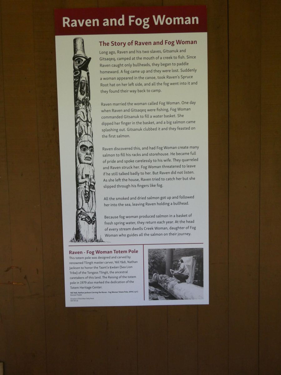
I continued up the street to check out a small but beautiful city park with some totems and then visited the Totem Heritage Center which is run by the same non-profit as the museum. The Totem Heritage Center preserves and perpetuates the living artistic traditions of the Tlingit, Haida, and Tsimshian peoples that gave rise to the original totem poles on display and provides the opportunity to discover, learn and practice Native arts to inspire cultural understanding.
The Totem Heritage Center houses a collection of 19th century totem poles retrieved in the 1970s from the Tlingit villages. The inhabitants of these villages moved to Ketchikan and other towns at the beginning of the 20th century in order to be near schools and churches, as well as the canneries, mines, and sawmills that offered employment leaving the totem poles abandoned. The government worked to retrieve and restore these totem poles and display them in various places around town.
"Yak’éi haat keeyateen í" - “It’s good you traveled here.”, ŁINGÍT (TLINGIT)
Since it was the Fourth of July, the town was having a parade that went right down the main street in front of my ship. I sat on my balcony and had a great view of the festivities.
Tonight, I had dinner in one of the specialty restaurants on board. Canaletto is the specialty Italian restaurant. I had short ribs braised in Chianti.
Tomorrow, we will be stopping in Juneau, Alaska. The ship left port at 3pm today to give us enough time to get to Juneau. We will be covering 273 nautical miles.
Downtown Ketchikan and Creek Street


Tongass Historical Museum & Totem Heritage Center


Totem Heritage Center


Parade


Leaving Ketchikan


